
As a companion to our Summer Reading Challenge, we are inviting the community to join us in a collective physical challenge: Bethlehem Walks! Use this form to submit your walking data to us, and we’ll compile it to show how far we’ve walked together as a town and include some fun information about the places we’ve “visited.” Include minutes walked, distance walked, or steps taken, as well as elevation changes (if you have it). Submit as often as you like. Adventure starts in Bethlehem!
Week 10 (8/25- 8/31)
Miles We’ve Walked This Week: 38
Miles Walked So Far: 901
Sargeant Jasper raises the flag over Fort Sullivan
It was a busy week last week, with everyone getting their last week of vacation and relaxation in before the end of summer. Last week was also the final week of Bethlehem Walks, and we finished our 10-week walk in Mount Pleasant, SC. Now part of the Charleston metropolitan area, the land of the town was originally occupied by the Sewee people. That changed in 1680, when European settlers claimed the land, calling the area “North Point.” Not long after, several attempts were made by the French and Spanish to take the land, but ultimately these attempts failed. Finally, just outside of Mount Pleasant, Fort Sullivan (later Fort Moultrie) was the site of the first victorious battle for Americans during the Revolutionary War. This battle is still celebrated in South Carolina as “Carolina Day.”
Throughout the 19th century, the main economic developments were made through plantations and slave labor. The majority of the population in Mount Pleasant throughout the 1800s and 1900s was made up of Black enslaved peoples. In September 1860, Mount Pleasant became the first area in South Carolina to pass a secession resolution, but soon the rest of the state joined the resolution to secede from the United States.
After the Civil War, one of the first African-American communities formed in the Charleston area. The 614-acre area was originally Remley’s Plantation and was purchased by John (sometimes listed as Robert) Scanlon, a freedman carpenter, who named the new town Scanlonville. Scanlon soon became the president and founder of the Charleston Land Company, which was formed by 100 local freedmen who had pooled together their limited resources in order to pay $10 per share to gain large tracts of land. These tracts were then divided into farm and city lots and distributed.
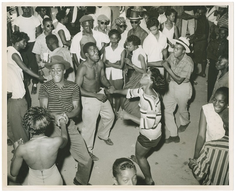
Dance Pavilion in Carr’s Beach, Maryland; similar to Riverside Beach
Riverside Beach, known as the largest and oldest of five “Black beaches” in the county, formed near Scanlonville during Jim Crow and segregation laws. It officially opened in 1930. Riverside featured a dance pavilion, bathhouse, playground, athletics field, and a boardwalk that wound along the Wando River. Many Black musicians played at Riverside, including Duke Ellington, Louis Armstrong, Count Basie, and B.B. King. These performances resulted in a number of night clubs developing in Riverside and in Scanlonville, as well as a hotel. This hotel, White’s Paradise, was frequented by James Brown.
Things to do in Mount Pleasant:
Although there are no museums in Mount Pleasant, there is still lots to see! The town has a number of sites that are Registered Historical Places, including Remley Point Cemetery in Scanlonville, which contains 41 marked graves ranging from 1867 to 1989, but residents claim there may be over 1,000 people, largely Black Americans, buried in the 3-acre cemetery. Other sites on the Registry include Auld Mound (one of 20+ prehistoric shell rings in South Carolina and Georgia), the Old Berkeley County Courthouse, and the USS Clamagore, USS Laffey, and USS Yorktown, among many more. Mount Pleasant is the site of many Civil War battles and historically significant sites, so history buffs will have plenty to explore!

Remley Point Cemetery, photo by Ammodramus, 2011
Apart from that, there are five major parks located in Mount Pleasant, including Mount Pleasant Pier, which is 1,250 feet long and stretches into the Charleston Harbor. Anyone looking to shop also has a few options! The Mount Pleasant Towne Center is home to over 65 retail stores. Every year, the shopping complex hosts “Fashion Camp,” where budding fashionistas can learn about the clothing industry and visit several stores in the area.
Total Elevation Gain: 31,845 ft
Since we already climbed the tallest mountain on Earth, we had to look into outer space to find our next mountain. Although we didn’t quite make it to its summit, we got pretty close to the top of Euboea Montes (34,449 ft), a mountain on Io, which is one of the many moons of Jupiter. Euboea Montes was discovered in the late 1970s thanks to Voyager 1, which launched in September 1977. According to the report by scientists Schenk and Bulmer, the mountain is made of the outer crust of Io, and it is continually sinking into the moon as more material forms on top. A similar example of this is the Black Hills of Dakota in South Dakota. The scientists were also able to identify a possible landslide off the mountain, which if their estimates are correct, would make the landslide one of the largest debris aprons in the Solar System. Debris aprons are piles of rock debris that settle below cliffs, and their slopes indicate a flow away from the cliff.

View of Euboea Montes, photo by Voyager 1, 1979
That wraps up 2024’s Bethlehem Walks! Thank you to any and all who participated in this summer’s first BW program!
In total, for all 10 weeks of Bethlehem Walks, we had 262 walkers take an estimated 1,039,116 steps, which took an estimated 10,624 minutes (or 177 hours or 7 days and 9 hours!)!
I hope you enjoyed learning about various towns in North America and the many mountains we climbed. Have a great Fall, and keep walking, Bethlehem!